


la tuile MPK

pierrounet
User
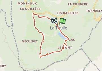

Length
8.8 km

Max alt
1016 m

Uphill gradient
264 m
Km-Effort
12.3 km

Min alt
778 m

Downhill gradient
266 m
Boucle
Yes
Creation date :
2024-02-29 12:35:06.908
Updated on :
2024-02-29 15:31:12.666
2h55
Difficulty : Difficult

FREE GPS app for hiking
 SityTrail
IGN / Geographical institutes
SityTrail Plus
The world is yours!
About
Trail Walking of 8.8 km to be discovered at Auvergne-Rhône-Alpes, Savoy, La Thuile. This trail is proposed by pierrounet.
Positioning
Country:
France
Region :
Auvergne-Rhône-Alpes
Department/Province :
Savoy
Municipality :
La Thuile
Location:
Unknown
Start:(Dec)
Start:(UTM)
270057 ; 5046428 (32T) N.
Comments